Esri UC Manager's Summit Recap
For the past few years, Esri has hosted the Manager’s Summit on Sunday as a pre-game, day-long discussion before the Users Conference for those interested in topics particular to leading a GIS focused mission. There is always a strong Wisconsin contingent and I thought it would be fun to gather everyone's highlights to share with WLIA membership. Judging from the many repeat attendees, there’s something for everyone from upcoming to seasoned leaders within their organization.
Innovation = Invention + Value
This quote was on everyone’s list. Invention is the part we techies like the best – and it’s important to make sure your team makes time to both engage in training opportunities but also share those newfound skills with the greater team. Create a culture of learning and sharing ideas without judgment, and if you’re in a leadership position, make clear that training and research time is just as important as that to-do list of apps and database maintenance tasks.
Value though, is the ingredient that will make your team shine throughout the organization and ensure future resources. Learn the language of whoever you’re sitting across from so they understand what you can do for them. The Finance team won’t care about maps and apps and portals. They will care about ROI and KPI though – so talk their talk. County Board Supervisors and Alderman won’t care about dashboards until they know that it can help them engage with their constituents and create a public understanding of the issues they get all those phone calls and e-mails about. Sometimes it’s our own boss that needs the education and we need to "manage up" to engage their help in promoting your program.
GIS professionals often have to learn about a whole lot more than GIS - the technology is just the tip of the iceberg. We have to understand capital project planning, culvert maintenance, zoning rules, a multitude of statutorily required programs, and the list goes on. I’m going to go out on a limb and say that it’s the thing we like about being in the land information community – being able to understand real world problems and tackling them with good solutions.
Tools for Success
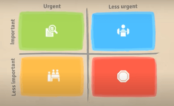 Sometimes tackling those issues require a solid, functional framework in which to think about the problem to organize thoughts. The Eisenhower Matrix was one tool mentioned to help avoid distractions from your core mission. They even have it built into the GIS Request Management Solution with two key questions: Is this task tied to a deadline? Will this task substantially improve services? By answering these kinds of questions up front when someone is at your desk demanding you do something for them, now you have a concise way to triage distractions vs priorities.
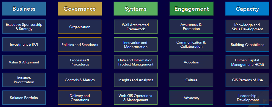
Another great resource is the Path to Geospatial Excellence website. In particular, consider assessing your program against these key areas and picking out those that need the most work to address first. There are five main areas of focus with detailed concepts under each that all drive success. While this graphic may seem pretty daunting, picking and choosing a couple areas of focus at a time can really help build momentum.
Governance in particular is one of the pillars that make or break a program. As one panelist put it, “Governance is the script”. Making policies and procedures that are well-documented can really speed up the development process by asking the right questions up front and make clear to those requesting services what is not only expected of you, but of them as the user. How many times have we created a web app that was urgent and necessary only to find a year later that no one ever used it? Were the right questions asked at the beginning? A life-cycle plan for any new initiative or application can really focus resources on the things that matter - not just roll-out but maintenance, training, and regular check-ins to ensure it still meets needs down the road and brings value to their team.
Managers put out fires. Leaders start them.
This quote caused a lot of discussion, and it was clear that people took this quote to mean different things. I think the key takeaway though was, if you’re only managing problems as they pop up, are you being a leader? Are you driving your organization to think bigger, to be more innovative, to avoid the default of “this is the way we’ve always done it”? It’s the old reactive vs proactive struggle. It’s hard to step out of the daily grind and try to steer a ship in a different direction, but in the end, another quote of the day, “Today’s impact will be tomorrow’s legacy.”
Is it scary or is it risky?
That stopped me in my tracks, personally. Who hasn’t put off having those tough conversations because we just don’t jive with the person we need to talk to, or we think they’ll dismiss us or have too many negative things to say? But sometimes those people are in decision-making or influencing positions and we just have to be brave to move the mission forward. Even if their first answer is “no”, you’ll never know what hurdles you can work to overcome later if you don’t ask the question in the first place. Invite policy makers into the conversation, even if it means the spotlight gets shone a little brighter on your team. After all, that great work shouldn’t be kept in the shadows. Don’t be afraid to celebrate your successes out loud!
Thanks to Kim Christman, Kelly Felton, Eric Damkot, and Jennifer Borlick for assisting me in gathering the top concepts we talked about during our day together. The full slide deck from the Summit is available here on the GIS Manager’s Group, where you can continue the conversation.
Geospatial Excellence Graphic taken from the event Powerpoint by Esri